





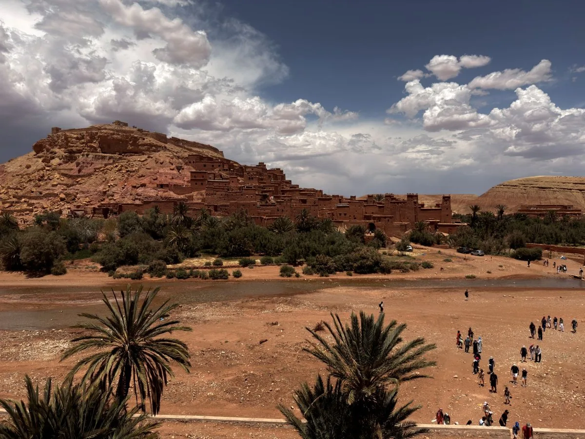
In the southern foothills of the High Atlas, in Ouarzazate Province, Aït-Ben-Haddou brings together dwellings and other earthen buildings within a walled enclosure. Inscribed on the World Heritage List in 1987, it is an example of traditional pre-Saharan habitation and earthen architecture in southern Morocco.
Its form can be read at several scales at once: houses grouped within the defenses, towers reinforcing the corners, and shared spaces that complete the settlement. The documented architectural description presents a compact ensemble; on its own, it is not enough to reconstruct how residents’ daily activities were distributed in every period.
Inside the enclosure: dwellings and shared spaces
The defensive walls have corner towers and an entrance arranged to make direct passage more difficult. Inside, the dwellings are closely grouped. Some are modest; others resemble small urban castles, with tall towers and upper sections decorated with motifs in earthen brick.
The documented ensemble also includes a mosque, a public square and a fortification. Outside the walls are grain-threshing areas. At the upper end of the village stand a large community granary—popularly known as “Ighrem n iqddarn”—and a caravanserai. The description also includes two cemeteries, one Muslim and one Jewish, and the shrine of Sidi Ali or Amer. Together, these features show the range of buildings and enclosures in the ksar, without by themselves establishing the precise use of each space throughout its history.
Earth and wood in the architecture
Earth and wood are the materials identified in the documentation. The ensemble brings together different earthen construction techniques characteristic of Morocco’s pre-Saharan regions. The dwellings and their decorative details show how these materials form part of both the walls and the façades.
The oldest buildings do not appear to date from before the 17th century, although the documentation notes that their techniques and structures had already spread through the valleys of southern Morocco in earlier periods. The age attributed to the buildings should be distinguished from the broader history of the techniques used to construct them.
The site record describes the earthen buildings as adapted to climatic conditions and in harmony with the natural and social environment. This assessment concerns the architectural relationship described, not a current technical evaluation of each building.
Conservation: distinguishing the historical record from current conditions
The World Heritage site record describes vulnerability associated with a lack of maintenance and regular repairs, which it links to residents’ abandonment of the ksar. It also notes that CERKAS—the centre devoted to the conservation and rehabilitation of the architectural heritage of the Atlas and Sub-Atlas zones—had difficulty monitoring respect for the property’s visual integrity. These observations are part of the available documentation and do not, on their own, establish the current condition of each structure.
Authenticity information dated 2009 states that the architectural style and the earth and wood materials had been preserved. It also describes efforts to retain wood in doors and windows opening onto the lanes rather than replace it with metal. The record mentions a few lintels and reinforced-concrete elements concealed beneath earthen render. These are historical observations, not an assessment of present conditions.
Protection and management: information from an earlier period
The protection documentation cites Moroccan legislation on historic monuments and sites, particularly Law 22-80. The same record notes a five-year management plan for 2007–2012, developed after two years of discussion and workshops with stakeholders, including local communities. It also records two management committees, one local and one national, and a coordinating role for CERKAS.
A documented assistance activity for 2008 describes a CRAterre-ENSAG mission that analyzed the property’s condition, made recommendations and defined action plans. The matters addressed included the fortification wall on the upper part of the rock and the building known as the community granary. This information documents that intervention, but does not establish that the plan, committees or the same measures remain in force today.
A settlement on an old trade route
The documentation places the ksar on a trade route connecting ancient Sudan with Marrakesh via the Dra Valley and the Tizi-n'Telouet Pass. Alongside the dwellings, defenses and shared spaces, this detail situates the ensemble within a regional history of movement. Without further documentation, it does not establish the volume, dates or goods involved in that trade.
Aït-Ben-Haddou stands out for its concentration of earthen buildings and the coexistence of dwellings, defenses and shared enclosures. Reading the place carefully also means respecting the limits of the record: the conservation and management descriptions here relate to documented periods, not to a current assessment of the site.
At a glance
Scope
Editorial overview; it does not constitute a visit or a technical assessment.
Sources and references
Ksar of Ait-Ben-Haddou ↗24/10/2026 UNESCO World Heritage Centre. “Ksar of Ait-Ben-Haddou.”
Ksar of Ait-Ben-Haddou ↗24/10/2026
Technical Assistance for the protection and development of Ksar of Ait-Ben-Haddou, Morocco ↗24/10/2026 UNESCO World Heritage Centre. “Technical Assistance for the protection and development of Ksar of Ait-Ben-Haddou, Morocco.”
Ksar of Ait-Ben-Haddou ↗24/10/2026
Ksar of Ait-Ben-Haddou ↗24/10/2026
Ksar of Ait-Ben-Haddou ↗27/10/2026
UNESCO World Heritage Centre - Document - Ksar of Ait-Ben-Haddou (Morocco) ↗06/11/2026 UNESCO World Heritage Centre. “Ksar of Ait-Ben-Haddou (Morocco).”